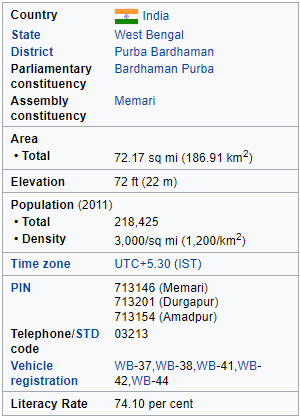
 Memari-I is a community development block that forms an administrative division in Bardhaman Sadar South subdivision of Purba Bardhaman district in the Indian state of West Bengal.
Memari is located at 23°10′34″N 88°06′25″E.
Memari-I CD Block is part of the Bardhaman Plain, the central plain area of the district. The area is surrounded by the Bhagirathi on the east, the Ajay on the north-west and the Damodar on the west and south. Old river channels and small creeks found in the region dry up in the dry season, but the Bardhaman Plains are sometimes subject to heavy floods during the rainy season. The region has recent alluvial soils.
Memari-I CD Block is bounded by Memari-II CD Block on the north, Kalna-II CD Block and Pandua CD Block, in Hooghly district, on the east, Jamalpur CD Block on the south and Burdwan-II CD Block on the west.
Memari-I CD Block has an area of 186.91 km2. It has 1 Panchayat Samiti, 10 Gram Panchayats, 171 gram sansads (village councils), 113 mouzas and 111 inhabited villages. Memari police station serves this block. Headquarters of this CD Block is at Memari.
Gram Panchayats of Memari-I Block/Panchayat Samiti are: Amadpur, Bagila, Daluibazar I, Daluibazar II, Debipur, Durgapur, Gope-Gantar I, Gope-Gantar II, Nimo I and Nimo II.
Memari-I is a community development block that forms an administrative division in Bardhaman Sadar South subdivision of Purba Bardhaman district in the Indian state of West Bengal.
Memari is located at 23°10′34″N 88°06′25″E.
Memari-I CD Block is part of the Bardhaman Plain, the central plain area of the district. The area is surrounded by the Bhagirathi on the east, the Ajay on the north-west and the Damodar on the west and south. Old river channels and small creeks found in the region dry up in the dry season, but the Bardhaman Plains are sometimes subject to heavy floods during the rainy season. The region has recent alluvial soils.
Memari-I CD Block is bounded by Memari-II CD Block on the north, Kalna-II CD Block and Pandua CD Block, in Hooghly district, on the east, Jamalpur CD Block on the south and Burdwan-II CD Block on the west.
Memari-I CD Block has an area of 186.91 km2. It has 1 Panchayat Samiti, 10 Gram Panchayats, 171 gram sansads (village councils), 113 mouzas and 111 inhabited villages. Memari police station serves this block. Headquarters of this CD Block is at Memari.
Gram Panchayats of Memari-I Block/Panchayat Samiti are: Amadpur, Bagila, Daluibazar I, Daluibazar II, Debipur, Durgapur, Gope-Gantar I, Gope-Gantar II, Nimo I and Nimo II.